© 2004-2017

Patagonia Bookshelf

Taming Virgin Land — Compañía Explotadora del Baker (1905-1908)
told by William Norris: Triumph and Tragedy

Locator (overview)

This map identifies the locations mentioned by William Norris in his letter and memoirs:

1. Neuquén 6. Baker district
2. Maquinchao 7. Santa Cruz
3. Tecka 8. Estancia Cóndor
4. Río Mayo 9. Punta Arenas
5. Paso Roballos  

Routes and approximate distances involved in drives:

1-2-3-4-5-6 (cattle): 1,000 miles
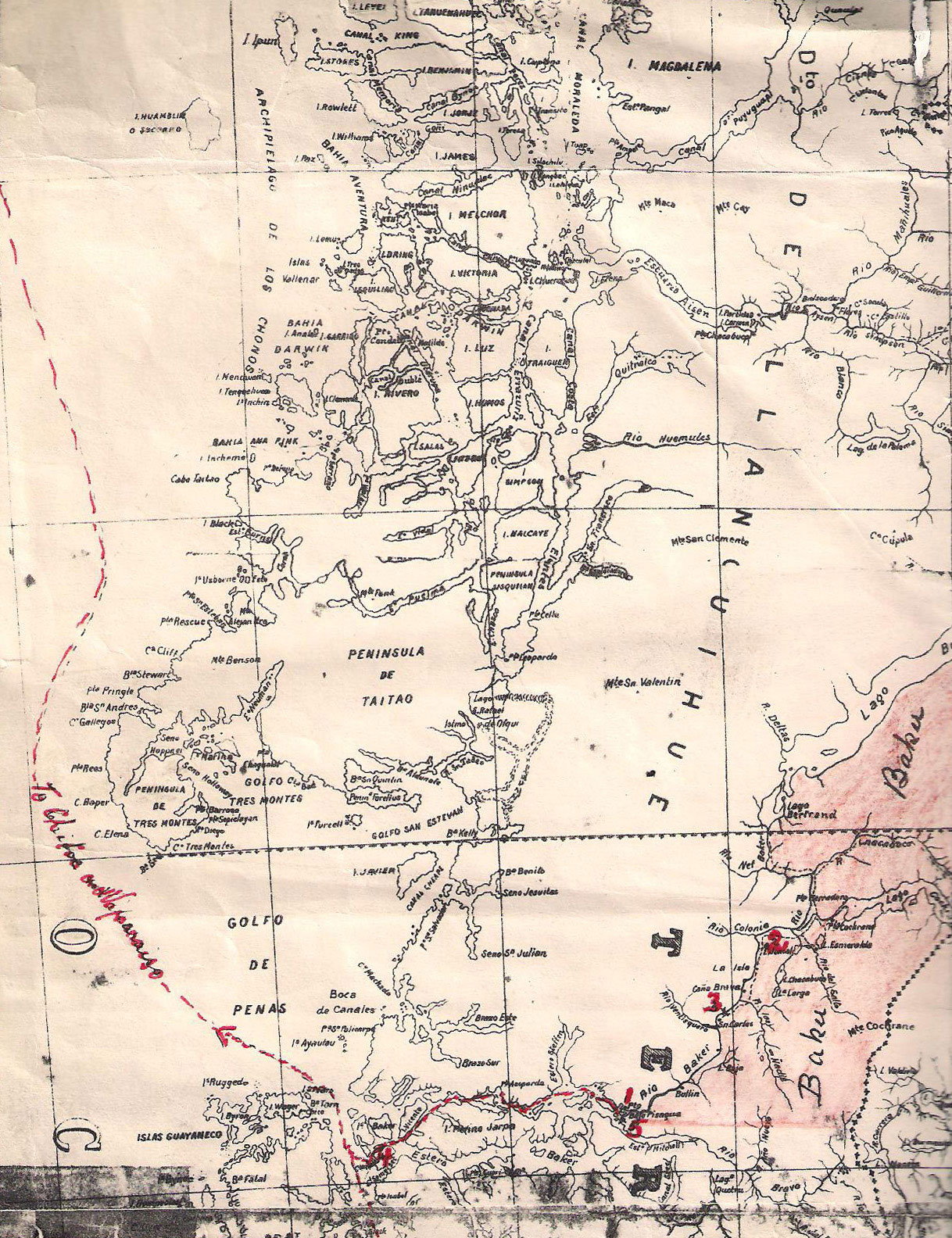
3-4-5-6 (cattle): 500 miles
8-7-6 (sheep): 500 miles

map

Tornero Map (published 1904)

We believe that the map reproduced here is the actual copy used by William Norris on his first land journey. We should not be surprised that Norris criticises it for its lack of accuracy, because it is apparent that the company had provided him with the best available survey of Chile, when what he most needed was a good map of the Argentine side.

Routes used (marked in red):

(a) exploratory expedition, from Puerto Santa Cruz (same route used for sheep-drive)
(b) two cattle-drives from Río Negro and Chubut
(c) sea passage from Punta Arenas via Magellan Strait and Messier Channel, onward to Chiloé and Valparaíso
(d) access to Bajo Pisagua from Hale Cove, on Messier Channel (by row-boat)

Five numbered locations in the Baker district (in red):

(1) Baker Port (Bajo Pisagua)
(2) La Colonia (headquarters of the estancia)
(3) Large waterfalls on River Baker
(4) Hale Cove (connecting point with passing steamers; 50 miles from Puerto Baker)
(5) Proposed new port (probably modern Caleta Tortel)

Other places marked:

(A) Punta Arenas
(B) Puerto Santa Cruz
(C) Ea. Cóndor (near Río Gallegos - sheep bought)
(D) Baker Concession (area shaded in light red)


legend
North-
west
North-
east
Centre
South
Composite
image
(scrollable)
3.2MB

River Baker District

This map shows Norris's area of activity (later developed by Lucas Bridges).


map
Acknowledgments: Thanks to Danka Ivanoff for providing the scanned images of the Tornero map (VI-2011)

Sources:
1. Locator: Adapted from "Great International Atlas", Prentice-Hall, 1981
2. Tornero: "Nuevo Mapa de Chile", Tornero, Santiago 1904, with hand-written annotation
3. Baker District: Adapted from "Atlas de la República de Chile", Instituto Geográfico Militar, Santiago 1970

Updated: 18-VI-2011