Patagonia Bookshelf
Official reports from Chilean Patagonia, 1867-1868 [text in Spanish]
Governor Riobó writes about Luis Piedra Buena, Indians and Alcohol
Setting the scene : Official Reports from Chilean Patagonia

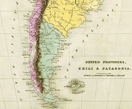
1866: All of Patagonia (in green on the map) is claimed by the neighbouring republics of Chile and Argentina: but, in practice, it is a land of wandering nomads, with only an occasional passing ship to break the monotony of its coastline.
On the Magellan Strait, there is a small Chilean settlement, comprising a fort and a few houses. The place is called Punta Arenas (a.k.a. Sandy Point).
A new governor arrives, intent on revitalizing the isolated community. However, things are not as simple as he had expected: the garrison is restive. Next, there is a disconcerting visitor, bearing a different flag — that of Argentina. He is Luis Piedra Buena. To learn what happens, read these official reports (in Spanish).
Sources:
1. Map of "United Provinces, Chili & Patagonia", by Jeremiah Greenleaf, 1840; from the David Rumsey Historical Map Collection. [Note: United Provinces (marked in yellow) was an early name for the future Argentina.]
2. Ministry of the Interior, Vol. 518, Chilean National Archive, Santiago
3. "Esposición sobre los acontecimientos que han tenido lugar en la Colonia de Magallanes", by Damián Riobó, 1868, available at Memoria Chilena